Coastal
Grasslands
Restoration
Incentive
Program
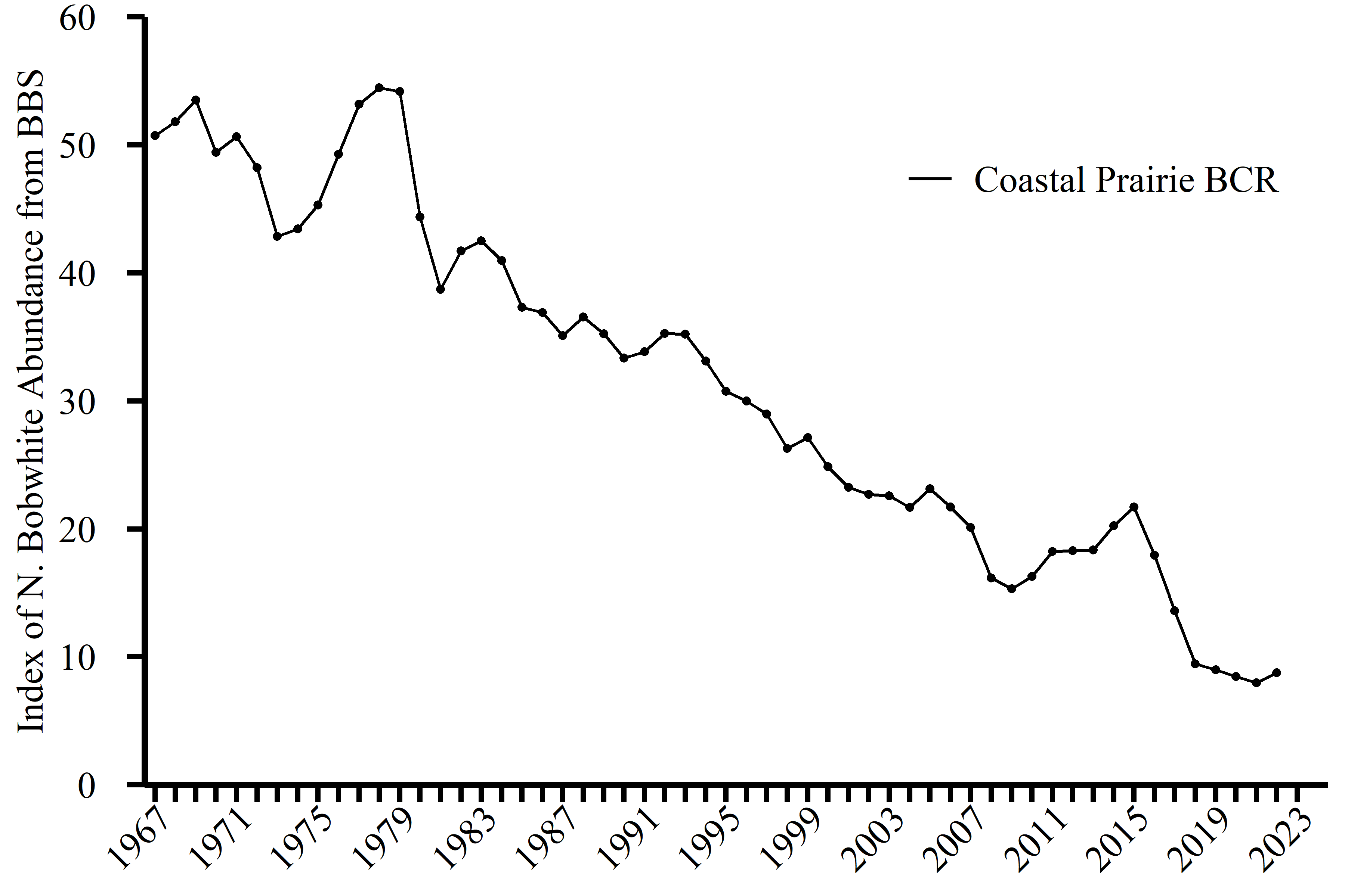
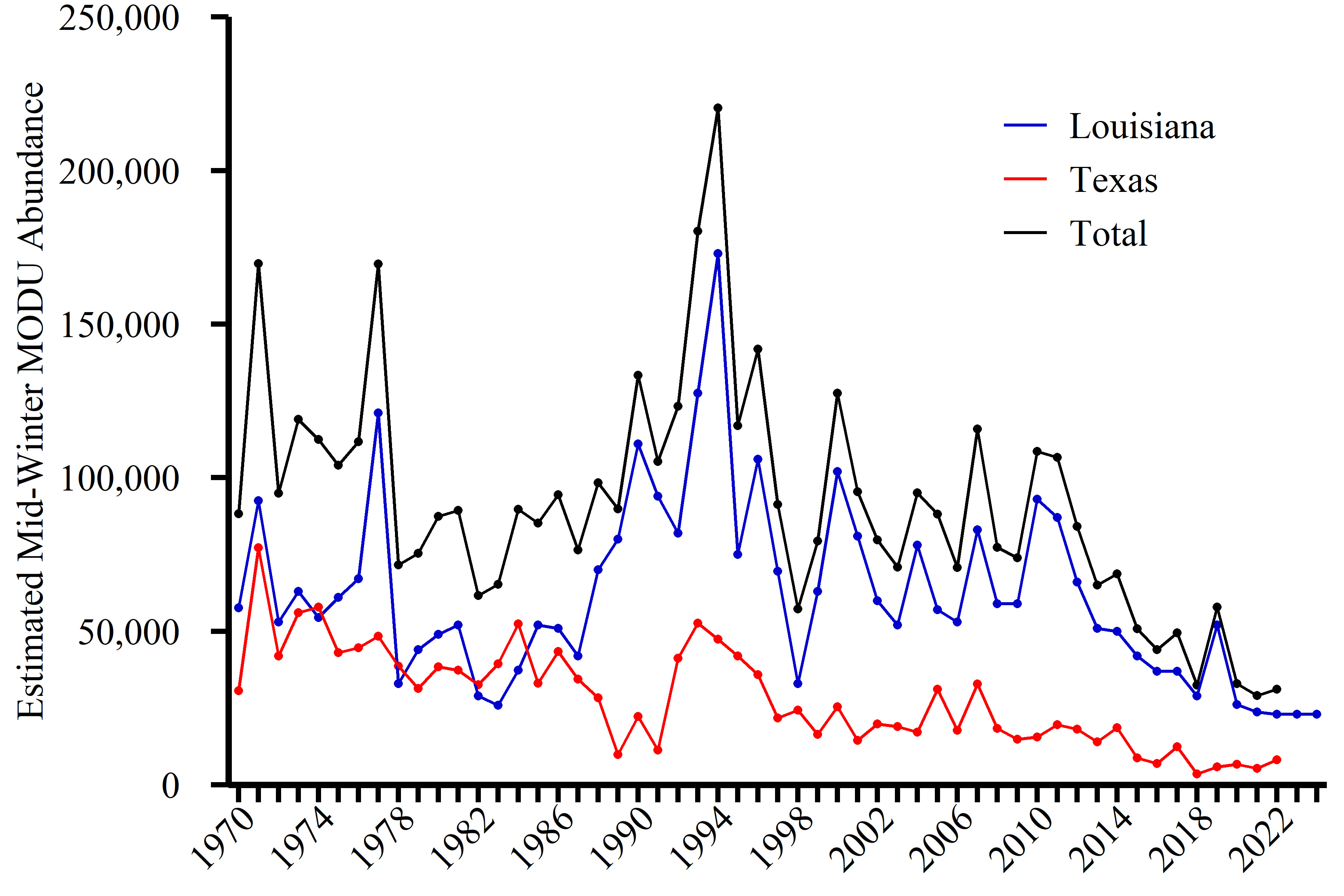
C-GRIP Details Focal Areas/Mottled Duck Decision Support Tool Enrollment Eligibility Proposal FormsFor more than 40 years grassland bird populations throughout Louisiana and Texas have been steadily declining. Among these declining birds is the Northern Bobwhite, a popular game bird and an icon of the American south. Also the Mottled Duck, a non-migratory North American waterfowl species, is reliant on grassland sites for nesting. Since 1981, the population of Northern Bobwhites and Mottled Ducks in Louisiana and Texas has decreased. There are many factors that contribute to these population declines, but the primary cause is the loss of available habitat needed to sustain these species. Conversion of native grasses to introduced pasture, overgrazing, suppression of fire, and brush encroachment have all had a significant impact on the ability of Louisiana and Texas grasslands to provide for the needs of Northern Bobwhite and Mottled Duck, as well as other grassland species. To address these population declines, it is crucial that private landowners are encouraged and supported in their efforts to improve habitat for these grassland birds on the lands they own and manage.


What Is C-GRIP?
The Coastal Grassland Restoration Incentive Program (C-GRIP) provides financial incentives to private landowners for conducting habitat treatments that improve suitability of grassland bird habitat on their property. In 2018, the Gulf Coast Joint Venture (GCJV) implemented the C-GRIP in the central section of coastal Texas. The GCJV expanded the program to southwest Louisiana in 2022. Modeled after the Natural Resources Conservation Service (NRCS) Environmental Quality Incentives Program (EQIP) and other similar programs, C-GRIP is a voluntary program that reimburses private landowners a set payment rate for identified practices that generally fall into the categories of brush management, prescribed burning, native grass reseeding, and prescribed grazing. C-GRIP encourages and supports private landowners in their efforts to improve grassland habitats.
What Makes a Grassland Good?
The goal of the C-GRIP program is to help provide healthy, native grasslands along the coastal region of Texas and Louisiana. The habitat descriptions provided below are the grassland structure that C-GRIP is trying to achieve. These important grassland habitats will address declining grassland bird populations within the C-GRIP delivery area. The photos and descriptions below approximate desired conditions within a C-GRIP project. If the grassland structure differs from any of the stated structural ranges, this indicates that the grassland is in need of some kind of management.


Northern Bobwhite, Loggerhead Shrike, and LeConte's Sparrow
Suitable grassland habitat structure for northern bobwhite, loggerhead shrike, and LeConte’s sparrow should have 300‒10,000 clumps of native bunchgrasses per acre. These clumps should be 12‒16 inches tall and at least 9 inches or larger in diameter (Brennan et al. 2005, Perez 2007). The space between clumps (e.g., interspace) can be bare ground or vegetation up to 2 inches in height. There should be 20-70% interspace with or without overhead screening to allow for ground foraging. Acres that have ≥10,000 clumps of native bunchgrasses should trigger a management action review and potentially some management action to decrease the number of native bunchgrasses clumps per acre.
Mottled Duck
Suitable mottled duck nesting habitat is within 1 mile of shallow water (i.e., brood-rearing habitat) (Krainyk et al. 2019) and we assume has a minimum of 3,000 clumps of native bunchgrasses per acre. These clumps should be 12‒16 inches tall and at least 9 inches or larger in diameter. The space between clumps (e.g., interspace) can be bare ground or vegetation up to 2 inches in height. There should be 10-50% interspace with or without overhead screening to allow for duckling movement to brood-rearing habitat.
A suitable mottled duck brood rearing wetland is inundated <18” from mid-February through July and maintains low (i.e., <9 ppt) salinity. Shallower wetlands (e.g., 6”) containing some mudflat may be more beneficial by reducing occupancy by wetland predators (e.g., alligator). The wetland should contain submerged aquatic vegetation or short (<12”) emergent vegetation covering 30-70% of the wetland to support abundant aquatic invertebrates. The wetland should also contain dispersed patches of dense emergent vegetation for duckling escape cover. Wetlands may come in the form of seasonal, semi-permanent or permanent wetland, coastal wetland, flooded rice field, or permanent crawfish aquaculture.
Project Managers preparing project proposals specific to Mottled Ducks are encouraged to use the currently suitable brood rearing and nesting habitat layers from the Mottled Duck Decision Support Tool to inform the preparation of your project proposal. Relevant layers are included in the map below:
The embedded webmap contains the C-GRIP Focal Areas and Currently Suitable Brood Rearing and Nesting Layers from the Mottled Duck Decision Support Tool. Layers can be turned on/off using the layer list on the left. The measuring tool (below the search bar) can be used to measure the distance from a proposed project location to the nearest Brood Rearing Habitat. To end a measurement line, double click.
Click Here to open the Mottled Duck Decision Support Tool Layers in a new window
Prescribed Grazing
Prescribed grazing is defined as using cattle, or deferring cattle from grazing, to achieve the grassland structure stated above.
Species C-GRIP Should Benefit
Other grassland species benefitting from C-GRIP: Dickcissel, Eastern Meadowlark, Painted Bunting, Lark Sparrow, Scissor-tailed Flycatcher, Bewick's Wren, Cassin's Sparrow, Field Sparrow, Atwatter's Prairie Chicken, Henslow's Sparrow, Northern Harrier, Sedge Wren, Burrowing Owl, Upland Sandpiper, Western Meadowlark, Savannah Sparrow, Yellow-breasted Chat, and Monarch Butterfly.
C-GRIP Partners

The involvement of multiple partners is a hallmark of successful conservation programs. The C-GRIP follows that model. C-GRIP partners have the opportunity to contribute to this important program that delivers grassland habitat outlined in several of the GCJV's planning documents. Partners can contribute in a variety of ways to make C-GRIP successful. Current C-GRIP partners and the respective roles they play is shown on the right.
How C-GRIP Works
Project proposals should be developed through collaboration between project managers and landowners and should follow recommendations laid out in any relevant plans including wildlife management plans, wildlife tax valuation plans, conservation plans, and grazing plans. It is not required that a plan be in place before a proposal can be developed, but it is highly recommended.
Qualifying practices and payment rates for Texas can be found here, and for Louisiana here. These practices and payment rates will change regularly, so landowners and project managers should use updated versions of the forms when planning treatments. All C-GRIP information and forms (qualifying practices and rates, project proposal form, project evaluation checklist, and reimbursement request form) can be found below . All practices follow NRCS specifications as identified in the NRCS Field Office Technical Guide.
The proposal submission process is handled through the C-GRIP Project Proposal Form. Project managers should use the C-GRIP Project Proposal Form located at the bottom of this page then follow these instructions:
- Fill out the C-GRIP Project Proposal Form. Have the landowner’s contact information ready.
- In coordination with the participating landowner fill out the C-GRIP Project Proposal Form for each treatment area in the proposed project. If the proposed project has more than one treatment area for which you are requesting funding, please include all treatment areas on the C-GRIP Project Proposal Form and submit as one project.
- Submit project proposal packet to C-GRIP Coordinator Steve DeMaso at steve_demaso@fws.gov
- If you have any questions about the process call Steve DeMaso (337) 262-7012 for assistance.
After project proposals are submitted, the C-GRIP Coordinator collects them and forwards them on to the C-GRIP Review Committee. An initial call for projects will occur approximately August of each year. Eligible and approved proposals will be funded throughout the year pending availability of funds.

C-GRIP Eligibility Requirements
- Treatment area must be at least partially located in a focal area. Focal areas extents can be viewed in the map viewer above.
- Treatment area must be on private land.
- Treatment area must be at least 25 acres in size.
- Treatment(s) being proposed must be on the eligible practice list and in accordance with C-GRIP Project Manager recommendations.
- Maximum funding for individual projects is $50,000 for Texas, and $25,000 for Louisiana.
- Landowner must be committed to maintaining improved state of habitat in project area for at least 5 years after project completion.
Locate Your Local Resource Professional
Texas Parks and Wildlife Department
Louisiana Department of Wildlife and Fisheries
C-GRIP Forms
Louisiana C-GRIP Forms
Texas C-GRIP Forms
For More Information or Questions About C-GRIP Contact
Steve Demaso, C-GRIP Coordinator
Office Phone: 337-262-7012
Email: steve_demaso@fws.gov

 700 Cajundome Blvd.
Lafayette, LA 70506
Phone: 337-262-7001 Fax: 337-262-7000
Copyright 2020 Gulf Coast Joint Venture - Webmaster


